John Hilmes / NYC case study / October 2026
DataBarge
Brooklyn Waterfront Links
A floating public connection above secured computing infrastructure.
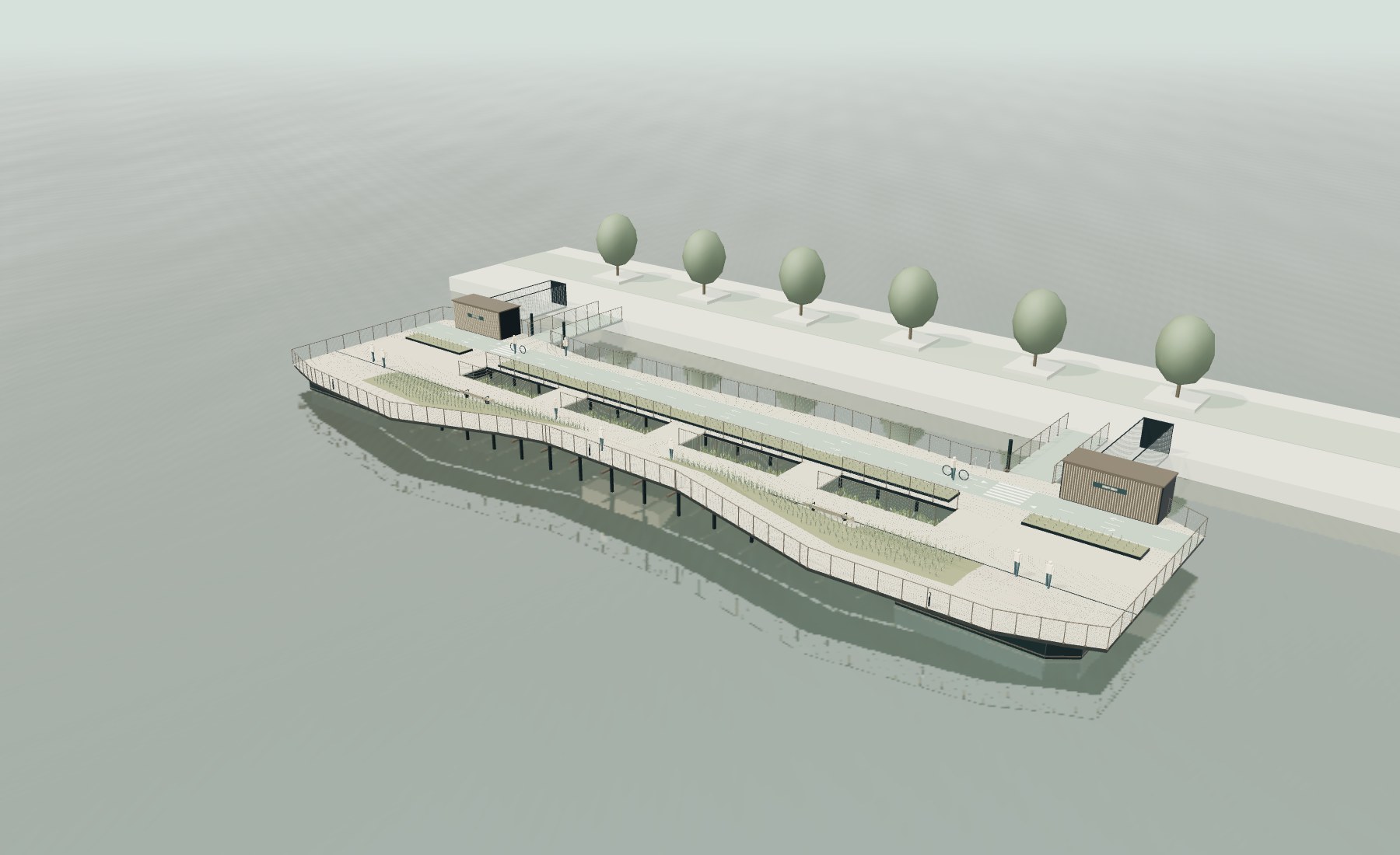
Proposed reference geometry. This is a digital architectural prototype, not a built or permitted facility.
DataBarge proposes to connect interruptions in Brooklyn’s waterfront walking and cycling routes with floating park segments. A commercial computing use below the public deck would be tested as a source of recurring support for the public connection.
Current request: assemble partners and fund a defined feasibility and prototype program for Gowanus Canal and Newtown Creek. Select one viable connection before commissioning a floating pilot.
Funding amount, financing terms and pilot budget are not yet set. This package supports an initial development discussion; it is not an offer of securities or a forecast of investment returns.
The civic proposition
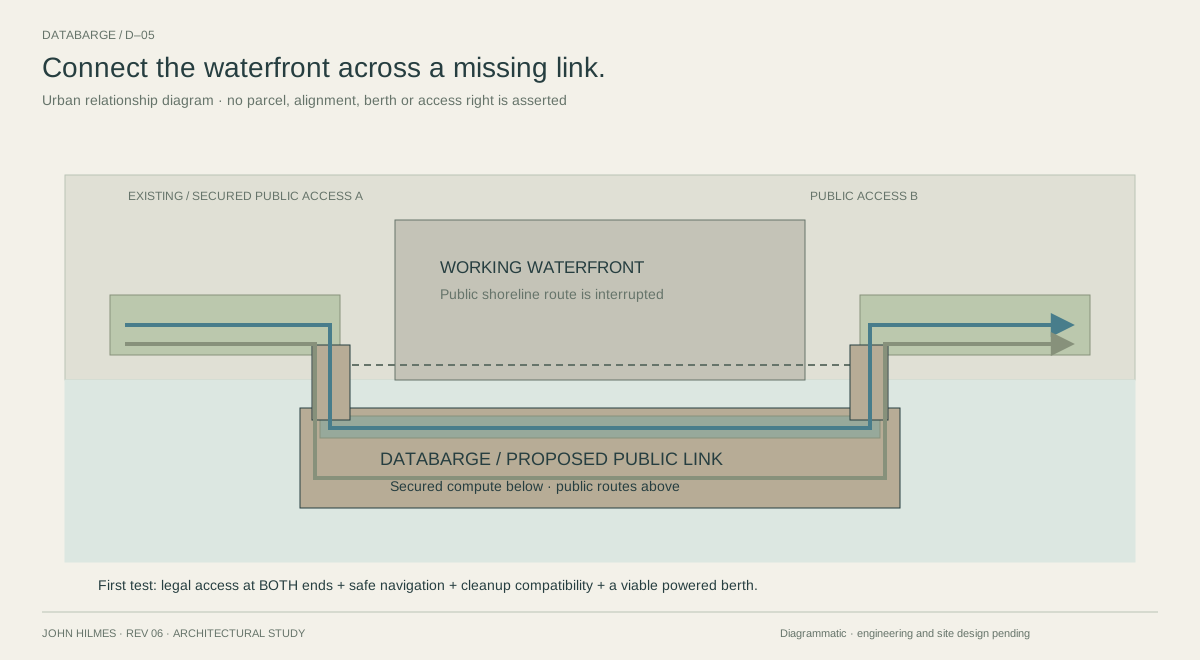
Complete a waterfront connection
The unit of value is a usable link between two public access points. The route should serve everyday walking and cycling, with places to sit, planting, and a clear boundary around private operations.
A public commitment
Secure both landing rights, define access hours, and assign maintenance responsibility. Budget for the public route even during computing downtime.
A working waterfront
Preserve vessel movement, industrial servicing and cleanup access. A floating link must coexist with those uses; it cannot assume their removal.
NYC’s 2025 Greater Greenways plan identifies closing network gaps as a priority. The Newtown Creek Nature Walk demonstrates an over-water public connection beside industrial operations. Its existing route prohibits bicycle riding; it is a precedent, not an assumed bike-network tie-in. [1, 2]
The architectural prototype
A public roof above dry, submerged halls
| Reference geometry | What it demonstrates |
|---|---|
| 72 × 23 m envelope | Four paired 12 m compute bays; 48 m and 60 m study variants. These dimensions are not a fit assessment for either NYC waterway. |
| 192 rack positions | A spatial layout only. Rack power, operating capacity, redundancy and utility demand remain to be specified with an operator. |
| 3 m cycle / 2.7 m walk | Parallel public movement, planted buffers, integrated seating and separate staff access. |
| Four end caissons | A proposed flotation arrangement around the submerged halls. Mass, ballast, draft and stability remain unverified. |
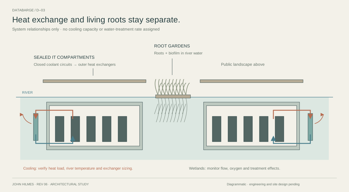
Floating root gardens add a monitored ecological pilot. They are separate from the cooling circuit and do not substitute for sediment cleanup. No PUE, cooling saving, carbon benefit or water-treatment rate is claimed.
Available now: editable 3D model, plan and section sheet, five system diagrams, and a traced archive of the original 2012 project. The current geometry is a new interpretation.
Two candidate contexts / no berth selected
Gowanus Canal and Newtown Creek
Gowanus Canal
A waterfront-access plan provides an existing civic framework. A prototype would need to complement planned and delivered access areas, rather than claim to replace them. [3]
Early constraint: EPA describes the canal as about 100 ft wide, roughly 30.5 m. The 23 m reference beam occupies much of that nominal width before clearances and moorings. This is a screening warning, not a channel survey. [4]
Test first: a narrower configuration, appropriate draft, two lawful endpoints, and compatibility with dredging, capping and bulkhead work. No sediment disturbance is assumed acceptable. [5]
Newtown Creek
Public access and industrial operations already coexist at the Nature Walk. That supports studying the relationship; it does not establish a specific available berth or permission to extend the route. [2]
Early constraint: the creek is a tidal Superfund waterway. EPA has selected an East Branch cleanup remedy; activity and restrictions must be checked for each candidate location. [6]
Test first: an industrial host with two public connections, sufficient navigation space, shore utilities, service access, and a route that preserves maritime operations.
Choose the site that can deliver a real public connection and a viable operating berth.
For both candidates, verify tidal levels and low-water depth before setting gangway lengths or retaining the assumed 4.25 m keel depth. Select planting for measured salinity and exposure. The earlier Chicago wetland precedent is not a NYC planting specification.
Screening should involve landowners, community representatives, marine engineers and the relevant agencies. USACE and NYSDEC provide the starting federal/waterways permitting framework; the full approval path remains to be determined. [7, 8]
The proposed development program
Fund evidence in stages
| Stage | Work to fund | Decision before the next stage |
|---|---|---|
| 1 / Select a link | Compare candidate gaps; survey navigation and low-water depth; establish endpoint rights; request utility and operator input; scope approvals. | At least one credible berth with two public endpoints, a power path and a compatible cleanup/navigation envelope. |
| 2 / Engineer a module | Develop a load and stability model, watertight enclosure, protected access, heat-rejection circuit and a costed fabrication package. | Independent review identifies an engineerable scheme and an achievable test program within an agreed budget. |
| 3 / Test on land | Run a sealed-enclosure and load-bank cooling test; build a full-scale bench/guard/planter detail; test inspection and replacement procedures. | Pre-agreed thermal, leakage, serviceability and public-edge criteria are met. Operator signs off on the next test. |
| 4 / Floating pilot | Deploy a separately engineered pilot at an approved berth. Monitor motion, water ingress, cooling, energy, ecology and maintenance. | Acceptable operating evidence, public-access approvals, a commercial host and a priced next-stage plan. |
The 12 m bay is the reference design unit, not a ready-to-launch vessel. The pilot’s final scale follows the site, engineering and budget. Public occupation begins only after the relevant safety and operating requirements are satisfied.
Evidence to report
Route connectivity and access hours; measured power and cooling behavior; water ingress and maintenance events; movement and gangway performance; ecological observations; quoted and incurred costs.
Acceptance thresholds, duration and reporting obligations must be agreed with the technical reviewers and funders before testing. No schedule or performance targets have been invented for this package.
One project / three participation cases
A distinct ask for each partner
Strategic partners
Ask: nominate an operator, a marine engineering/fabrication partner, and a potential host. Contribute a load specification, service requirements, berth screening and priced scope. The outcome sought is a technically defined pilot with an operating sponsor.
Early-stage investors
Ask: fund bounded development milestones once the sponsor, scope and governance are established. Release follow-on funding against site, engineering and test evidence. An investment amount, vehicle and terms must follow the cost plan; none is represented as agreed.
Public and civic partners
Ask: support route-gap analysis, public-access agreements, community review and ecological monitoring. Explore eligible public-realm or research funding without treating a grant as secured or assuming it can subsidize private compute equipment.
Commercial hypothesis
An operating partner could lease the infrastructure or contract for computing capacity. A defined part of the operating budget would support the public route. The pilot must compare this structure with a conventional onshore facility plus a separately funded public connector.
Cost basis to obtain: fabrication and marine works; electrical/fiber connection; cooling and IT systems; park construction; monitoring; insurance; maintenance and replacement; contingency and decommissioning.
No customer commitment, partner agreement, revenue, cost saving, grant eligibility or return is established. Public-space operating costs must remain visible in the economics.
Investment discipline
The questions that decide the case
| Question | Required evidence |
|---|---|
| Does it connect? | Mapped public endpoints, access rights and hours, gangway geometry across tides, and a maintainable route with clear walking/cycling transitions. |
| Can it occupy the water? | Surveyed berth, vessel-clearance study, cleanup compatibility, applicable approvals, and land/water rights. Reconfigure or reject sites that fail this screen. |
| Can it operate safely? | Marine and structural review, protected egress, fire strategy, watertight boundaries, ventilation, rack replacement and emergency procedures. |
| Can it cool reliably? | Operator-defined IT load, seasonal water data, heat-exchanger sizing, pumping energy, thermal-plume/fouling assessment and a monitored test. |
| Does the business work? | Fabricator and utility quotes, operating model, insurance input, customer evidence and comparison with conventional alternatives. |
| Who keeps the link open? | A proposed public-access agreement, funded maintenance reserve, accountable operator, closure protocol and end-of-life/removal obligations. |
Development team to assemble: John Hilmes as concept author and architectural lead, with a naval architect, structural and MEP engineers, a data-center operator, fabricator, waterfront/environmental advisors, cost consultant and public-realm partner. These roles are proposed; appointments are not represented as secured.
DataBarge should advance only where the public connection and the computing use strengthen the same feasible project. If the combined configuration fails the site or operating tests, a smaller connector or a different berth is a legitimate outcome.
Evidence and next conversation
What is ready to review
Design: an interactive architectural prototype with editable geometry, separated public/staff circulation, submerged dry halls, a park roof and floating root gardens. Next commitment sought: a scoped feasibility effort, technical participants and candidate host introductions.
NYK, NTT Facilities, Eurus Energy and MUFG have published a quay-based floating-data-center concept. This provides a relevant industry reference; it does not validate DataBarge’s site, costs or performance. DataBarge’s proposed distinction is its explicit public waterfront connection and corresponding operating obligations. [9]
[1] NYC DOT / Greater Greenways, 2025.
Network expansion and gap-closing policy.
[2] NYC DDC / DEP / Newtown Creek Nature Walk.
2021 over-water connection; current access and bicycle rules.
[3] NYC Planning / Gowanus Waterfront Access Plan.
Section 139-50 and Appendix B maps.
[4] EPA / Gowanus Canal.
Site description and nominal width.
[5] EPA / Gowanus cleanup.
Cleanup and community updates.
[6] EPA / Newtown Creek.
Tidal estuary and East Branch cleanup.
[7] USACE / New York District.
Regulatory program and authorities.
[8] NYSDEC / Tidal Wetlands.
Permit program and early consultation.
[9] NYK consortium / Port-based floating DC.
Official concept announcement.
References checked 19 October 2026. The two waterways are case-study candidates. No parcel survey, property commitment, utility allocation, engineering certification or fundraising agreement is supplied.
Open the 3D model ↗ / Five design diagrams ↗ / Archive and research ↗